Singapore's best-kept secrets: places most tourists walk straight past
Most first-time visitors to Singapore move through a fairly predictable circuit: Marina Bay Sands, Gardens by the Bay, Sentosa, Chinatown, Little India, Orchard Road. These are all worth seeing — they’re on the circuit for a reason. But Singapore is far more layered than this, and some of the most interesting parts of the city are in the gaps between the landmarks.
Here are places worth rerouting for.
| Best for | Repeat visitors and anyone with 3+ days in Singapore |
| Cost | Mostly free; a few SGD 3–15 food and museum stops |
| Getting there | All MRT-accessible or a short Grab ride |
| Time needed | Half a day each; can combine two in one day |
| Best time | Weekday mornings for the quietest version of each |
Tiong Bahru: the neighbourhood that kept its character
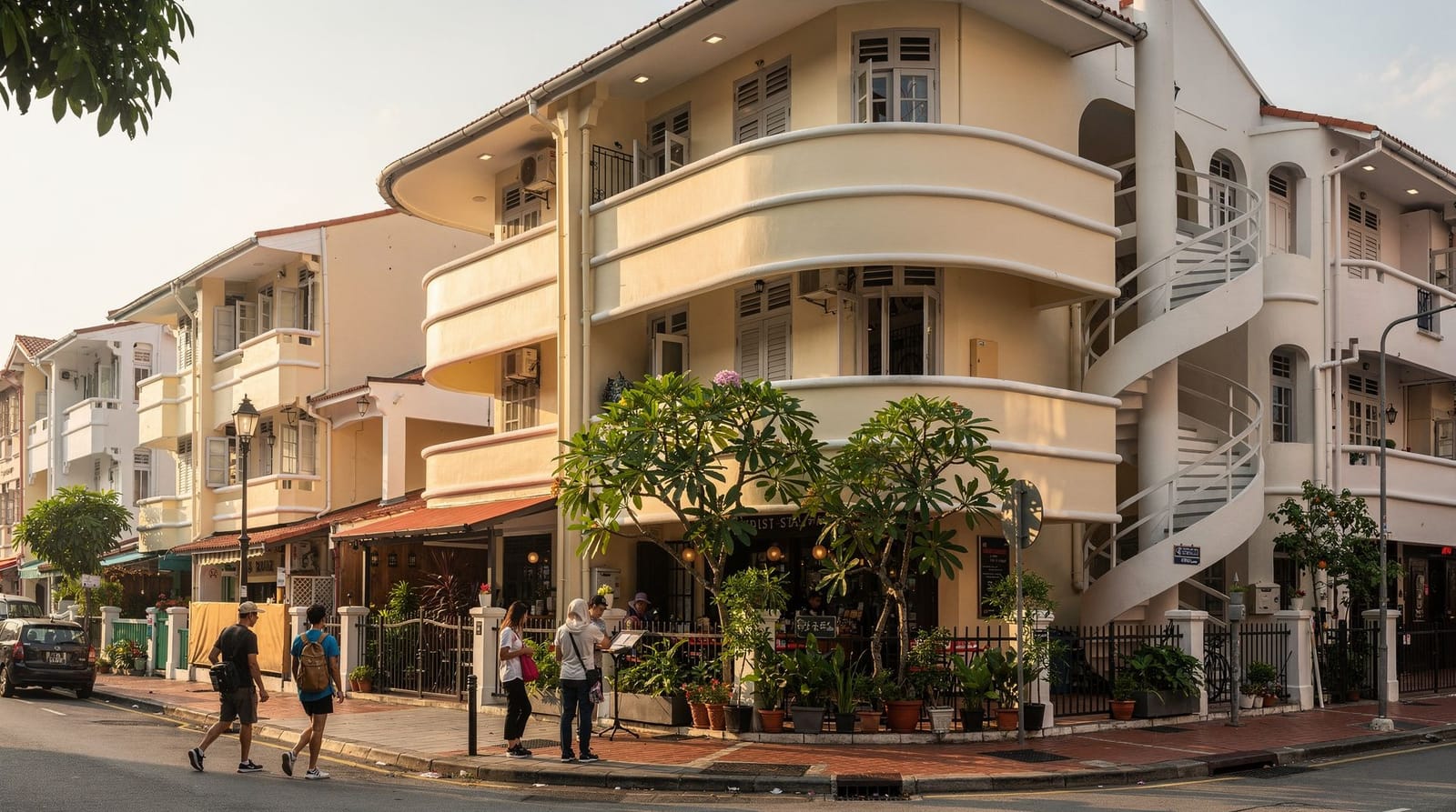
Tiong Bahru is Singapore’s oldest public housing estate, built in the 1930s under the British-era Singapore Improvement Trust, and its architecture is unlike anything else in the city. The buildings are low, white, Art Deco in their curves and louvred windows, and arranged in a configuration that gives the neighbourhood an unusually village-like feel for a city of this density.
It’s become well-known among Singapore residents and food-savvy visitors over the past decade, but it still flies under the radar for most tourists, perhaps because it requires a deliberate detour rather than being on the way to anywhere obvious. The Tiong Bahru Market is one of the better hawker centres in the city — the chwee kueh (steamed rice cake with preserved radish) at the stall on the second floor is consistently excellent and costs about SGD 3 for six pieces.
The Tiong Bahru guide maps the neighbourhood properly. Allow two hours for a proper wander including coffee at one of the independent cafés that have colonised the street-level retail spaces in the estate.
The Southern Ridges: a trail most people don’t know exists
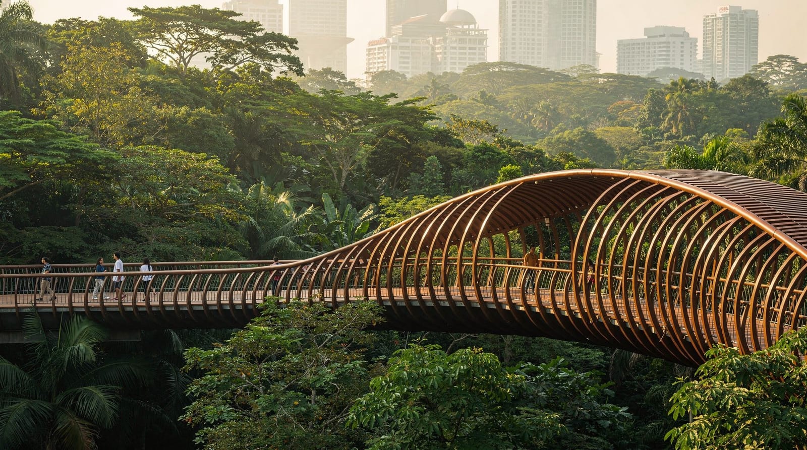
The Southern Ridges is a 10-kilometre trail connecting Mount Faber, Telok Blangah Hill Park, Kent Ridge Park, and HortPark — running along a series of elevated ridges in the south of the island. The trail passes through secondary rainforest and comes out at the Henderson Waves bridge, a wave-shaped pedestrian bridge 36 metres above the forest floor that is genuinely beautiful and almost entirely absent from Singapore’s standard tourist material.
The most popular starting point is the cable car station at Mount Faber (take a Grab; it’s not easily MRT-accessible) and walk toward Henderson Waves. The full trail takes about 3–4 hours. The ridge sections are mostly shaded. It is free and one of the better things you can do in Singapore if you want to understand that the city is built in and around significant green infrastructure.
The Southern Ridges guide covers the route and the entry points.
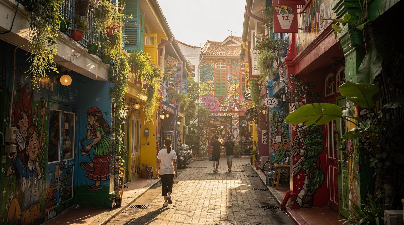
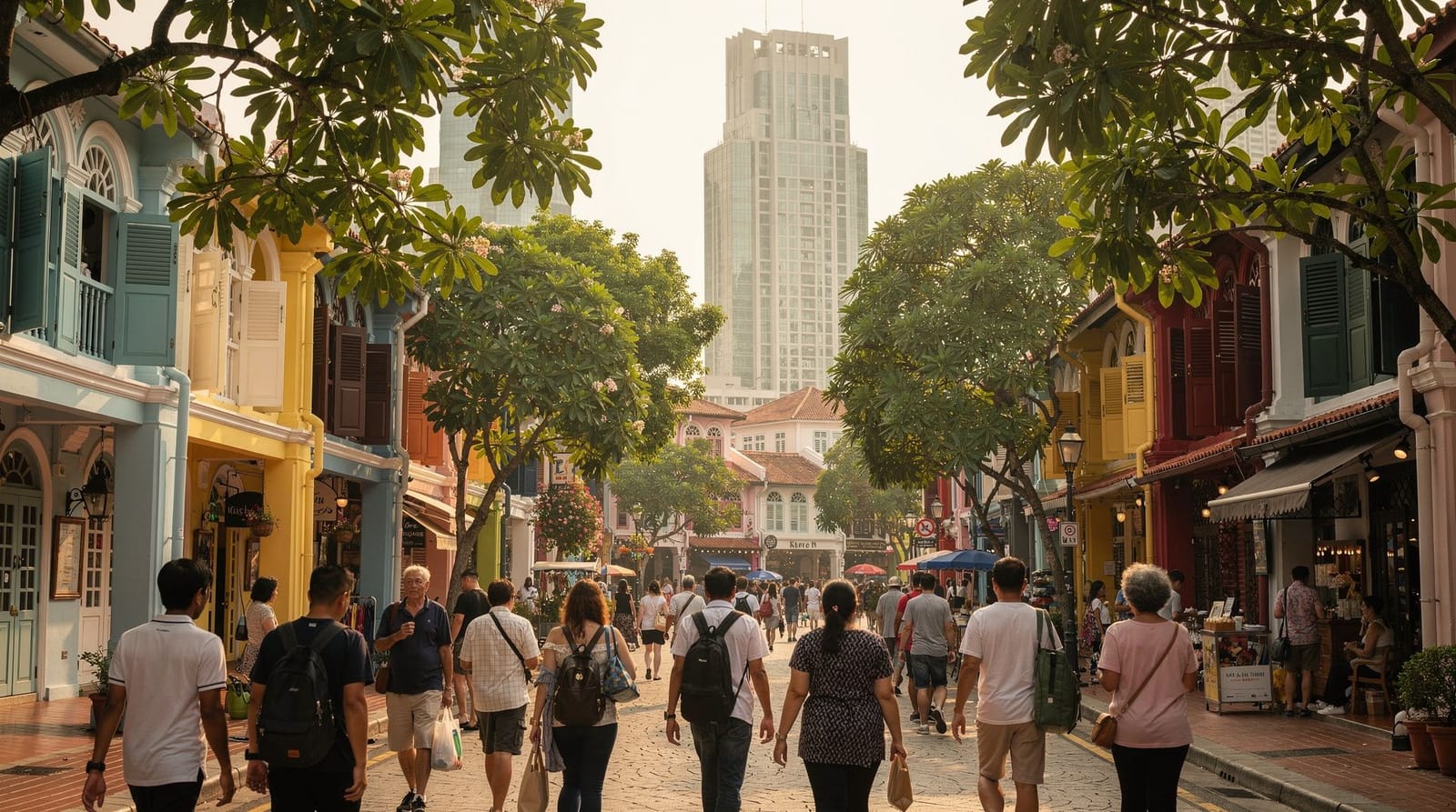
Haji Lane in Kampong Glam: the lane, not just the corridor
Everyone goes to Haji Lane — it’s in every Singapore guidebook, it photographs well, and it has good cafés. What most people miss is the wider Kampong Glam neighbourhood around it. The Sultan Mosque on North Bridge Road is free to enter (outside prayer times, with modest dress) and its interior is considerably more impressive than the exterior suggests — the dome is the largest in Singapore and the space underneath it is unexpectedly calm.
The perfume shops on Arab Street — many of them family-run and in the same location for decades — sell oud, attar, and rose-based perfumes at prices far below what you’d pay at a department store for inferior products. This is a genuinely specific Singapore shopping experience that has nothing to do with the malls.
Walk north from Haji Lane into Aliwal Street and Jalan Kubor — quieter, less photographed, with a couple of independent bookshops and a distinctly different atmosphere from the instagrammed café strip.
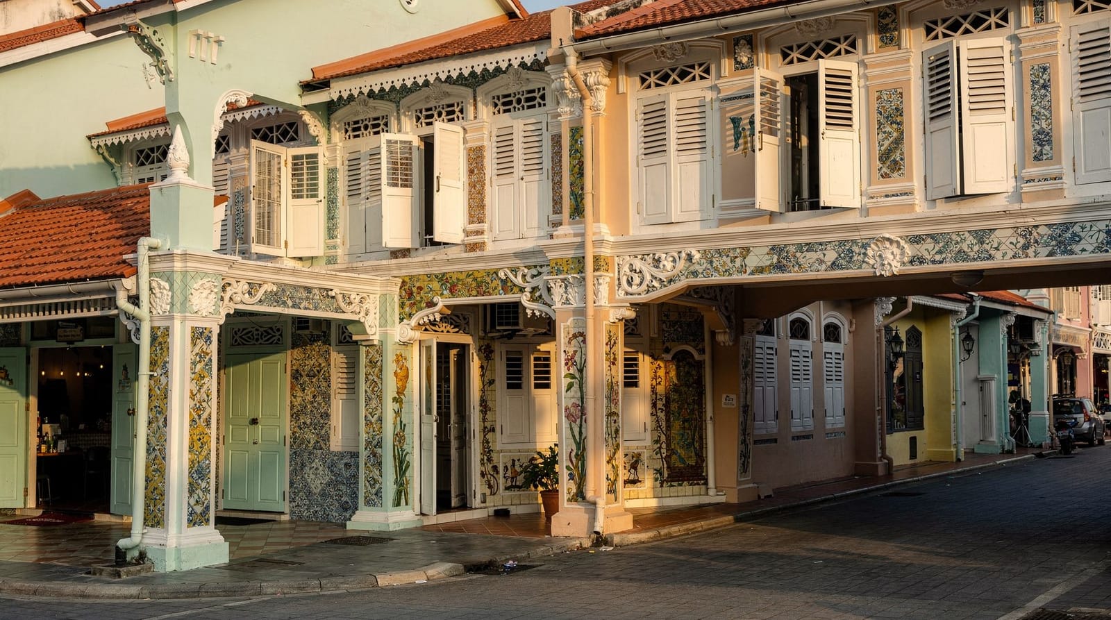
Katong and Joo Chiat: Peranakan Singapore properly
Most visitors get a superficial version of Peranakan culture — the brightly painted shophouses on Koon Seng Road in Joo Chiat are in every Singapore photography list, and justifiably so. What often gets missed is the depth of the neighbourhood around them.
Katong and Joo Chiat is where a significant part of Singapore’s Peranakan (Straits-born Chinese) community lived and still lives. The food is different here — laksa has a slightly different regional character, the kueh (traditional cakes and snacks) are more varied and more carefully made than you’ll find in tourist-facing Chinatown. Kim Choo Kueh Chang on Joo Chiat Road has been making nyonya dumplings and kueh in the same building since 1945.
The neighbourhood is a 20-minute MRT ride from the centre and feels like a different Singapore from the Marina Bay corridor. Read the katong-joo-chiat Peranakan guide before you go — it makes the details much more legible.
Coney Island: Singapore’s quiet wild east
Most visitors have never heard of Coney Island (also called Pulau Serangoon), which is accessible by foot from Punggol at the north-east end of the MRT and is a narrow strip of secondary forest and coastal habitat that Singapore has deliberately kept low-development. The island has a cycling and walking trail, a small beach on the south side, and a collection of wildlife — monitor lizards, otters occasionally, various bird species — that feels incongruous with the high-density city 20 minutes away on the train.
It is a half-day excursion requiring more planning than most tourist activities in Singapore, which is probably why visitor numbers stay manageable. Go on a weekday morning and you’ll have most of the trail to yourself.
Bukit Timah: the forest that shouldn’t exist in a city this dense
Bukit Timah Nature Reserve contains more plant species than the entire continental United States, packed into a patch of primary rainforest at the geographic centre of the island. The main hill climb to the summit (163.6 metres, Singapore’s highest natural point) is a genuinely demanding walk by Singapore standards — steep, humid, and shaded the whole way. Long-tailed macaques are common along the trail; keep food out of sight and don’t feed them. The Bukit Timah hike guide covers the different trail lengths and difficulty levels, since not every route requires the full summit climb.
Singapore highlights and hidden gems private car tourFort Canning Park: the hill everyone walks past
Fort Canning Hill sits directly behind Dhoby Ghaut MRT and is visible from Clarke Quay, but a surprising number of visitors never actually go up it. This is a mistake. Fort Canning has been continuously significant in Singapore’s history — Malay royalty, a British fort, WWII command bunker — and its current form as a park includes the Battlebox (a preserved WWII command centre, ticketed), one of Singapore’s older Christian cemeteries, and a series of garden terraces that get quieter and greener as you climb.
The park connects to the Armenian Church (the oldest church in Singapore, free to enter) and to Clarke Quay via a pleasant shaded path that takes about 15 minutes. It’s a good middle-ground option on a day when the heat is wearing and you want green cover without committing to a full nature trail.
The Singapore at night version of these places
All of the above change significantly after dark. The Southern Ridges at night — particularly the section around Henderson Waves — is illuminated and almost empty of visitors; the city lights below the ridge are spectacular. Kampong Glam at night, when the shophouses on Bussorah Street are lit from inside and the Sultan Mosque glows, is one of the more atmospheric urban environments in Southeast Asia.
The best photo spots guide covers several of these locations with notes on timing and access. Singapore’s golden-hour light is typically in the late afternoon from around 6–7pm, before the sky goes quickly dark around 7:30pm year-round.
Which one fits your remaining time
If you have limited time left in your trip and are choosing between these, here’s a quick way to decide:
| If you want… | Go to |
|---|---|
| Architecture and coffee | Tiong Bahru |
| A serious nature walk | Southern Ridges or Bukit Timah |
| Food and heritage together | Katong and Joo Chiat |
| Quiet wildlife, low effort | Coney Island |
| History with minimal walking | Fort Canning Park |
| Photography beyond the obvious | Haji Lane, Bussorah Street, Kampong Glam |
Each works as a standalone half-day; Tiong Bahru and Fort Canning are close enough to combine into one longer day if you want two in a single outing.
A principle for finding more
The best approach to finding what Singapore doesn’t put in its official tourism material is to take the MRT to a neighbourhood you’ve heard nothing about and walk. The getting around guide lists the standard interchange stations. Queenstown, Redhill, Kembangan, Bedok — any of these put you in residential Singapore where the food is better, the streets are quieter, and the sense of stumbling onto something unplanned is real.
The city is more discoverable on foot than its reputation for heat suggests, provided you are armed with a working phone for navigation, an EZ-Link card, and a willingness to have lunch at a kopitiam where the menu is partially in Chinese and the default assumption is that you know what you’re ordering.
FAQ
Which of these hidden gems is best for a first-time visitor with only one extra half-day? Tiong Bahru — it’s centrally located, requires the least walking effort, and delivers the clearest sense of “a different Singapore” for the time invested. Fort Canning Park is the second choice if history interests you more than architecture and coffee.
Are these places actually still “hidden,” or are they well known locally? Most are well known to Singapore residents but genuinely under-visited by tourists, which is the more accurate framing. Tiong Bahru and Katong have become popular with food-savvy visitors over the past decade, while Coney Island and the Southern Ridges remain quiet even by local standards.